There is some controversy about both the name and the extent of the ‘original’ part of Northampton, representing as it does the greater part of the Saxon burgh. In recent times local councils and planners have attempted to rebrand the area as ‘Spring Boroughs’ but only since the late 20th century, to the general annoyance of former residents. The defined area of the Boroughs has been the subject of much-heated debate. Again in recent times, the Northampton Borough Council (and its successors) have sought to extend the area defined by the Boroughs.
These debates though have gone on for at least the past 100 years as the pages of the journal of the Northamptonshire Natural History Society and Field Club reveal in an article by Mr A. Adcock. This description is particularly interesting as it excludes the area south of Castle Street and King Street.
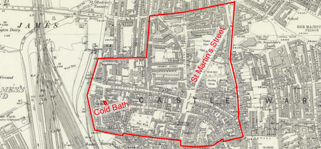
Please click on the map to access the interactive map …
THE BOROUGHS — NORTHAMPTON.
An undefined portion of Northampton has been called “The Boroughs” for a considerable time, probably for centuries. The name appears to be a survival of mediaeval Northampton. Some Northampton people will dispute the spelling, and would have it “Burrows,” and regard it as akin to the “Rookeries” to be found in most old towns. But I assume it is our old word “borough” in a plural form, the alteration being made when Northampton people used the word without knowing precisely what they meant by it. I take it to be analogous to the phrase “Going to Town.” In Northampton it was usually “Down the Boroughs” as an indication of the neighbourhood in which somebody lived or where some small domestic occurrence took place.Whilst it would be quite safe to say that the top portion of Scarletwell Street is about the centre of the Boroughs it is impossible to state exactly how far the area extends. It is certainly within a rough circle bounded on the North by Grafton Street, West by the present St. Andrew’s Road, South by Castle Street and King Street, and on the East by Sheep Street.
These boundaries lead to the suggestion that the name dates from the time when the people of Northampton, or by far the major portion of them, dwelt in that area, and no other, when in fact, it was the inhabited borough. The first town wall, Anglo-Norman, according to Dr. Cox, and as shown on the reconstructed map in the “Borough Records,” ran where Grafton Street is now and then from the site of Grafton Square, declining a little to the South, straight to the river. The latter portion of the line is wholly conjectural, though there is more than probability that the position of the other portion is correct. A map in the possession of Messrs. Markham and reproduced by the Rev. R. M. Serjeantson in his “Priory of St. Andrew, Northampton” 1 shows that the South Wall of St. Andrew’s Priory ran on the line of Grafton Street from Regent Square to Grafton Square. This wall may have been the old wall of the town. It was necessarily the Northern boundary of the Boroughs. From Grafton Square St. Andrew’s wall ran where Lower Harding Street is to Spring Lane and then by a right-angled turn down Spring Lane to near the river. The Boroughs could not be North nor West of this wall.
The North wall of the Castle was about where Castle Street now runs, which gives us the Southern limits of the Boroughs. The Town Hall was in the very centre, in Scarletwell Street. The road from London instead of running up the present line of Bridge Street bore to the left after passing South Quarter, and went up College Street or thereabouts, and reached the Mayorhold along Silver Street. The Mayorhold, Dr. Cox and the Rev. R. M. Serjeantson to the contrary, I still believe obtained its name from being the “holding” of the Mayor, or Community, and used for public purposes, especially for the town’s meetings or common assemblies. Because it has been found written “Mare Hold” is no more evidence to the contrary than the one or two instances where ” Burrows ” has been found in nineteenth century letters. It is merely a guess that it was named from being the market place for a particular commodity, like Horsemarket, Sheep Street, Drapery, Wood Hill, and the forgotten Hogmarket. It is certain that nearly all the sixty houses of late Saxon Northampton were clustered in the area I have attempted to define. When the town walls were extended soon after 1300, it was not to enclose more houses, but was a strategic measure to enclose more land. It was at this time that the new Town Hall was built at Wood Hill, a proof that the population was moving Eastward. It could not go West because of the river.
I take it that the “Mayor of Scarletwell” dates from this time. “The old Town Hall”, wrote Henry Lee, a town clerk, “was in a little close adjoining to the last houses on the right hand in ye lane going from ye Mayorhold to Scarletwell”.
This lane is now Scarletwell Street. Until the end of the reign of Queen Victoria it was the practise of some of the inhabitants of “The Boroughs” to meet in some public house and elect the “Mayor of Scarletwell”. This custom may have originated the very year that the real Mayor was first elected outside the Boroughs. Before 1300, the Mayor was chosen at a town’s meeting, I suggest on Mayorhold. The erection of a Town Hall at the commencement of Abington Street did not alter the mode of election, nor did it necessarily alter the place. We know, however, that afterwards the Mayor was annually elected at a town’s meeting in either St. Giles’ Church or the churchyard. In 1489, the municipality was converted into a close corporation and the election of Mayor thereafter took place within closed doors at the new Town Hall. Perhaps when the common people found themselves deprived of the hilarity of an open election in St. Giles’ churchyard, they flocked to the historic place of election in Mayorhold, and chose by show of hands a ” Mayor of Scarletwell.” Centuries later when the close Corporation was electing Members of Parliament in the Town Hall the populace had a mock election on the Market Square. On one occasion someone sent the names of the two selected on the Square to the Speaker of the House of Commons, with the result that thenceforward Northampton had household suffrage. Although the election of the ” Mayor of Scarletwell ” was annual, the appointment, in recent years at any rate, was held for life, or at least so long as “his worship” was physically and financially capable of doing the accustomed honours of election night.
The last “Mayor of Scarletwell,” I believe, was Mr. Thomas Mawby, who died in office on April 8th, 1909. at the age of 82. The “Northampton Daily Reporter” recording the decease of “Sir” Thomas Mawby said: “He and Mr. G. H. Johnson were the leading members of a corporation which met at the Crispin Arms and sometimes ventured to criticise municipal matters, but usually their meetings were devoted to social amusement. He was called ‘Knight of the Bristle’, being a shoemaker.” In the latter half of last century occasionally a reference to the election would appear in the local newspapers.
The district, mean as it is to the casual eye, is rich in archaeological association, though few relics remain. There is no part of the town which has so many awkward street corners, evidence of ancient ways. There are quaint street names : Bell Barn Street, for example. St. Martin’s Chapel was in Broad Street, formerly St. Martin’s Street. The Blackfriars Monastery was south of Mayorhold, along Hogmarket Lane, now Bath Street, so called from a Cold Bath there in the eighteenth century. Blackfriars Lane is where Castle Street is now. St. Mary’s Church was where the playground is in Doddridge Street, formerly Quart Pot Lane. North of the churchyard of St. Mary’s was a polygonal space on which was formerly Castle Hill, an artificial mound thrown up probably in Cromwellian times and having nothing whatever to do with the Castle fortifications. Scarlet Well still exists, though bricked up. Lastly, Jewry was in the neighbourhood of Silver Street, where remains of the synagogue were existing within the last fifty years. 2
- Journal of the Northants. Natural History Society, Vol. 13., pp. 136—7.
- Journal of Northamptonshire Natural History Society and Field Club, vol 21, (1923) pp162-163
© Copyright : Graham Ward. All rights reserved.