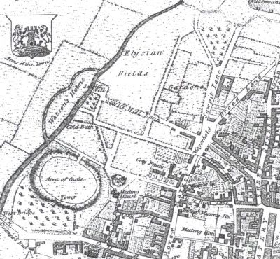
The Boroughs in 1831 was dominated by the Norman Castle which covered a vast area from its north gate in Fitzroy Street to the Bailey adjoining West Bridge

The street layout is familiar. The Mayorhold, allegedly the site of the original Market Square, is clearly marked.
Scarletwell Street leads down to the eponyous well famed since Norman times for its waters which were used in the dyeing of red cloth for the Royal Court.
Spring Lane has yet to be laid out; at this stage it would have been a rough path to the spring which gushed water downhill to the River Nene. Forty years later this lane would be the location for the new Board School
The Saxon defences of the town can be seen following the lines of Bearward Street and Silver Street as they curve round to join up with Scarletwell and Bath Street
The Blackfriars, one of the four orders of friars in the town in medieval Northampton, was situated off the Horsemarket but on this map their religious house is incorrectly identified as “Greyfriars”. Today on this site stands Blackfriars House which is a modern block of two bedroomed flats; the Cloisters Pocket Park opposite is named after the dwelling of the 13th century religious brotherhood
Everywhere in the Boroughs there are the reminders of a historic past.
© Copyright : Graham Ward. All rights reserved.