An earlier post about the Civil War, 1643: Skirmishes in Kingsthorpe Hollow drew attention to a stream in Kingsthorpe Hollow that is now largely forgotten – Wallbeck. This stream is one of many water assets in the town that in former times would have played a significant role in the life of the inhabitants than they do today.
Using data from 25-inch Ordnance Survey maps surveyed in 1883, before much of the expansion of the town had started, the water features are much more prominent. These have been identified and overlayed onto a modern map.
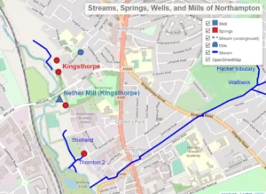
An interactive map is available here, allowing zooming into areas of interest. The layers can also independently be hidden with the checkboxes. As you zoom in, other items may appear that are otherwise hidden in the zoomed-out view.

Any updates, corrections or local names for the streams are welcome.
© Copyright : Graham Ward. All rights reserved.