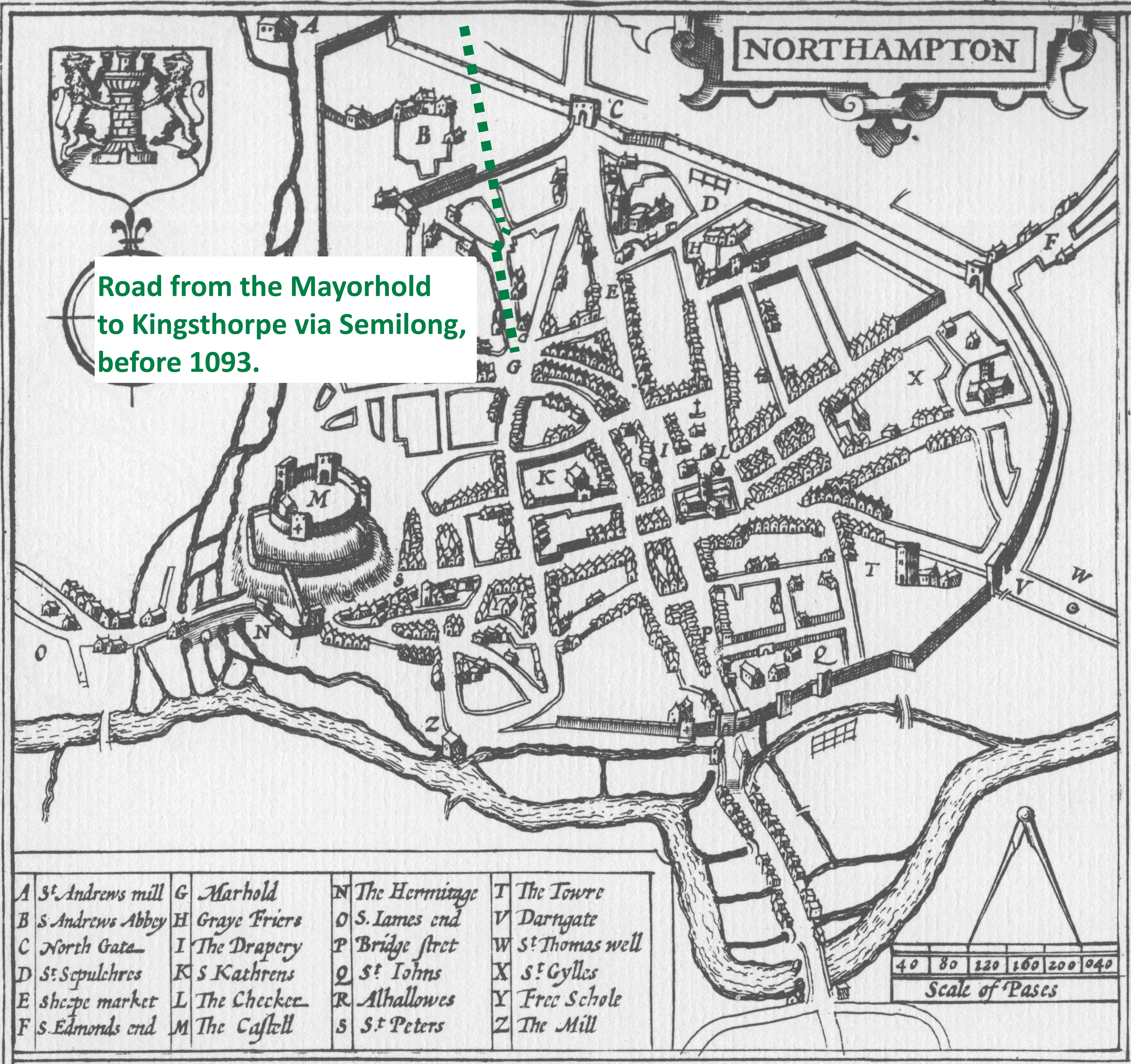
Semilong is an area of Northampton that was developed in the late 19th and early 20th centuries. The regular pattern of streets heading in an east-west direction down from Semilong Road to St Andrews Road has added to the close community feel of the area. It might be assumed that before this area became part of expanding Northampton it was largely open fields. This however is only partially true and an oversimplification. In the past, the area was considerably different. Before the Medieval town of Northampton expanded its perimeter and built a new boundary wall, Semilong Road was the main road from Northampton towards Market Harborough and Leicester, rejoining the modern alignment of the Harborough Road at Kingsthorpe Hollow. This is well illustrated in Alderman Frank Lee’s conjectural map produced in 19531.

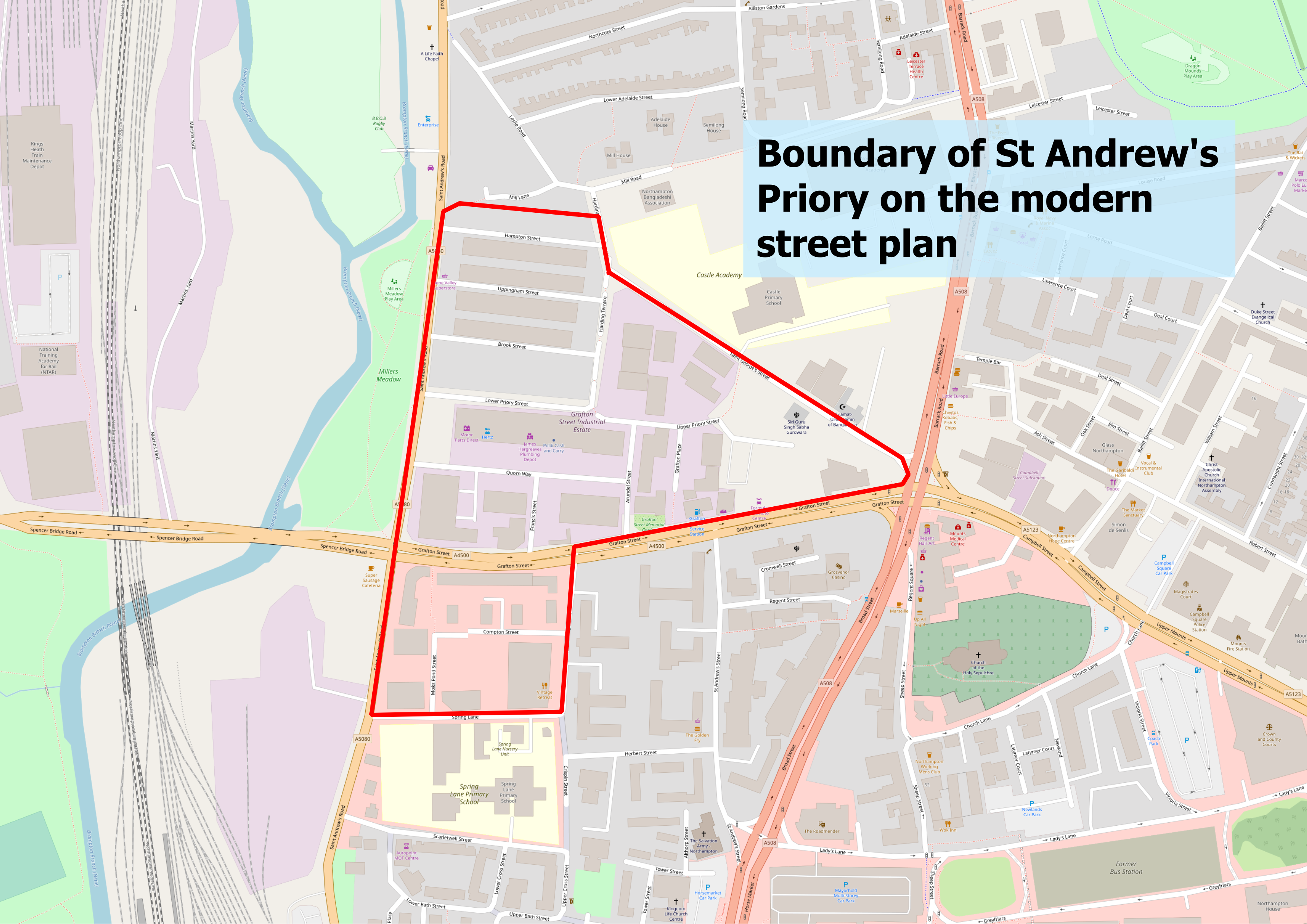
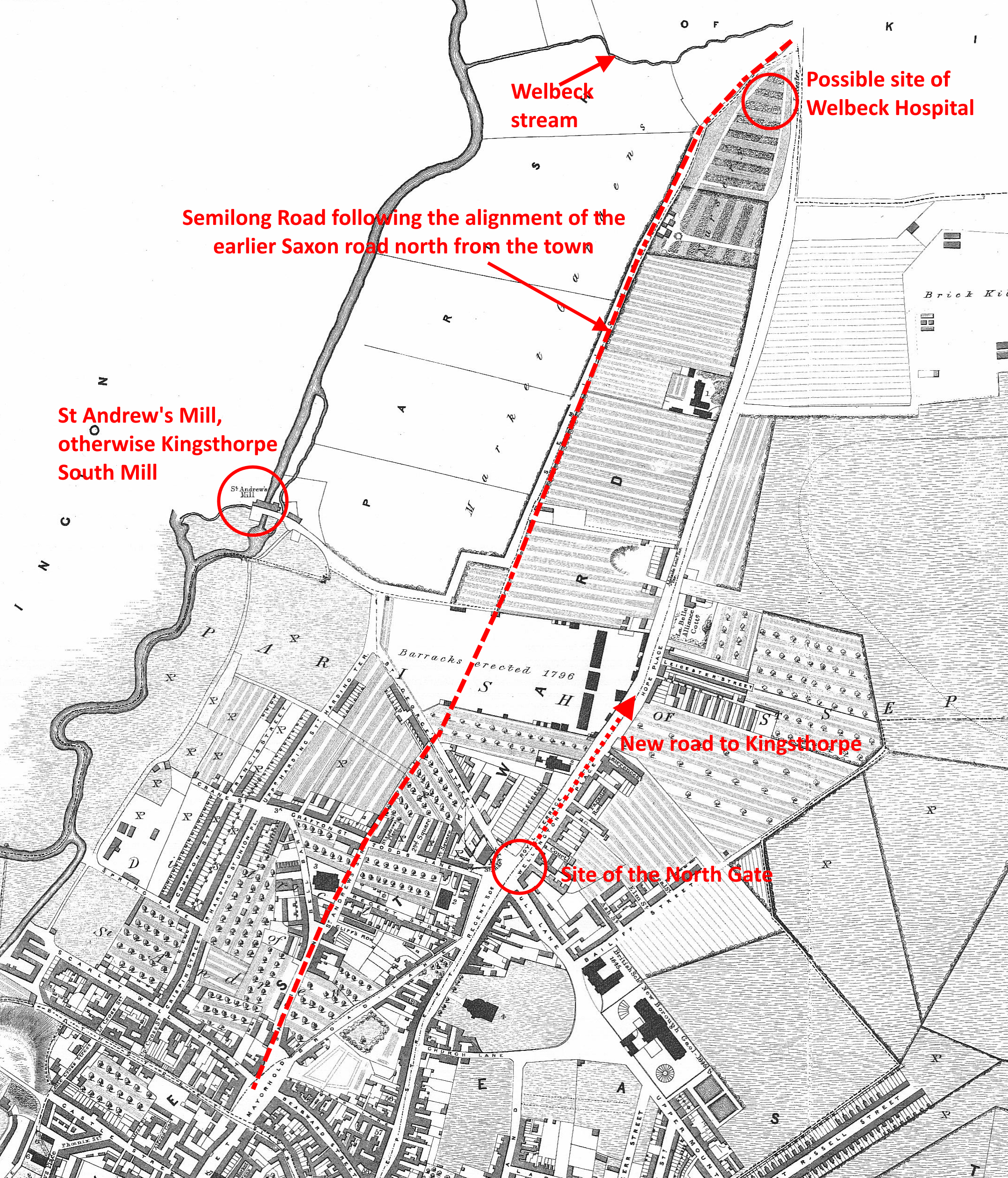
There is no mention of St Andrew’s Priory in the Domesday Survey (1086) and it is believed that the Saxon town of Northampton lay partially in ruins after the attacks and occupation by the Danes. Simon de Senlis I is credited with founding the Priory of St Andrew probably between 1093-1100 2. As the boundary of the priory is shared with the new extended town wall it seems likely they were planned if not built at the same time. It would have been near this date that the main route north from the town moved from the Semilong Road route to the new Kingsthorpe Road alignment from the North Gate located near what is today Regents Square.
There is no known surviving map but we can infer this from the archaeology of the early street pattern of the town. This is perhaps more clearly seen in Speed’s 1610 plan of the town.
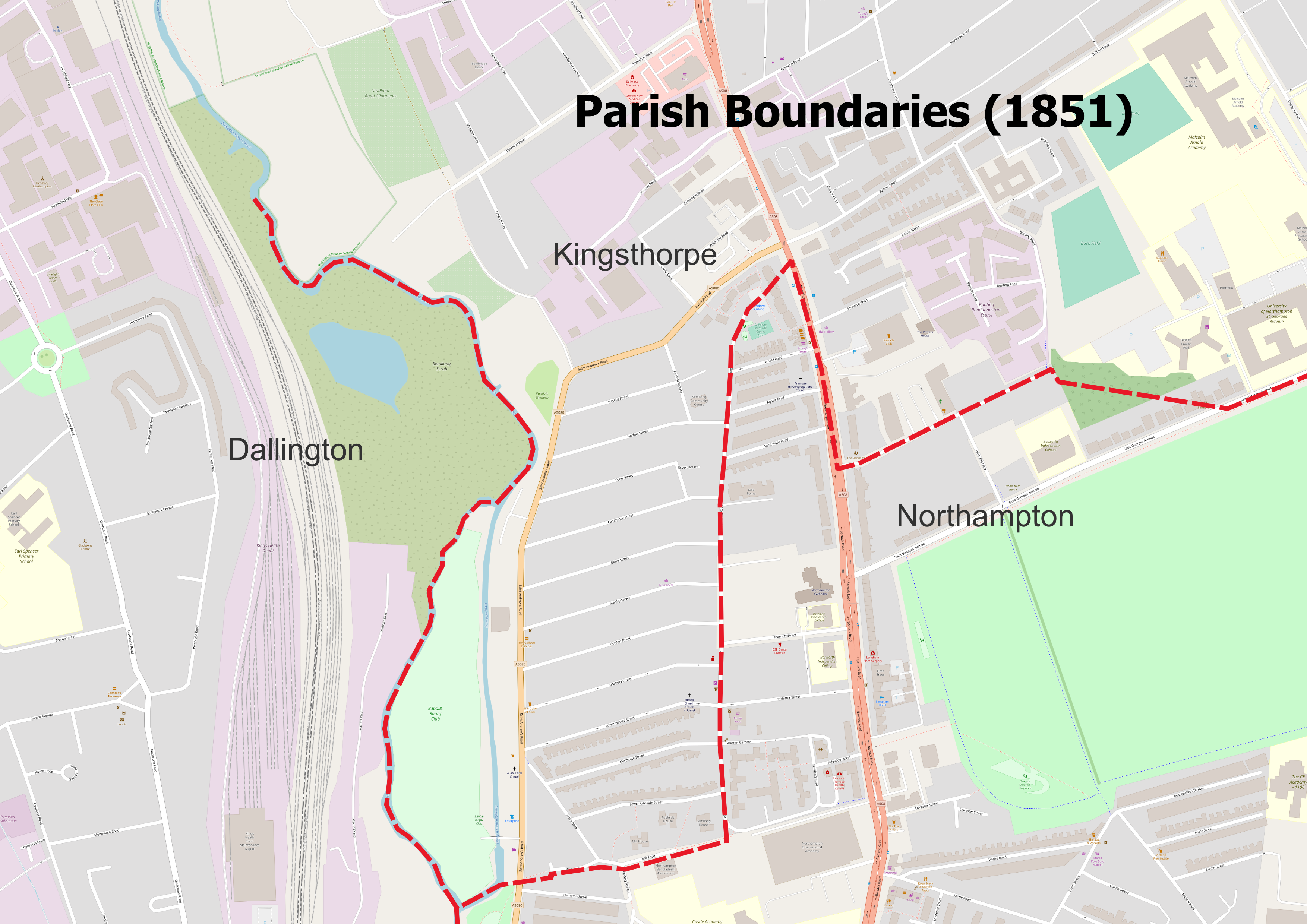
Until Northampton itself expanded further in the late 19th century the area to the west of Semilong Road was in the parish of Kingsthorpe and the area to the east of Semilong Road terminating abruptly as Kingsthorpe Hollow was in Northampton. The name Semilong is itself interesting, and in this form probably unique. The 280,000 entries in the Gazetteer of British Place Names3 does not reveal any similar places in Britain and Google Maps only identifies the name with Northampton. However, if we turn to historical sources we can begin to understand its origins.
Southmyllewong – the origins of the name
A Kingsthorpe deed cites a, now lost, will of Henry Coup of Northampton referring to 3 acres of arable land in the field of Kingsthorpe above the furlong called ‘Southmyllewonge’4.
Another early deed refers to a “Walter Delepert bought of John Pekke Bailiff in the town of Kingsthorpe half acre of land in the furlong he calls Sowthmylnewonge.”5
Unravelling “Southmyllewonge”, it can be read as “South-Mill-Wong”. Kingsthorpe had three watermills North or Far Mill (later known as Walker’s Mill), Nether Mill at the bottom of Mill Lane in the village and South Mill, also known as St Andrew’s Mill, adjacent to Miller’s Meadow (or Paddy’s Meadow) in St Andrews Road. Wong (which sometimes appears as Wang) is an Old English word meaning, a piece of meadowland, an open field’.
Taken together, “South-Mill-Wong” describes the area between St Andrews Road and Semilong Road as a meadow adjoining the Kingsthorpe South Mill.
Cut Throat Lane
Not the most welcoming address, but one that was not uncommon in Victorian England, if not earlier. It is possible that some streets acquired this name by repute although more often the name is used to refer to a narrow lane or shortcut with no footpath and walls or hedges to either side. The last 150 metres of Semilong Road before it joined the Kingsthorpe Road at the Hollow was known by this appellation. The road was “made up” and rejoined Semilong Road with Kingsthorpe Hollow in 18896.
Welbeck or Wallbank?
The area we now refer to as Kingsthorpe Hollow was until the late 19th century often referred to as Wallbank7 which took its name from the Welbeck stream that passes under the Kingsthorpe/Harborough Road at the lowest point. This stream will be familiar to the properties on Balfour Road today.
Kingsthorpe Hollow itself, a more modern name for the area, was the site of a minor battle in the English Civil, as I have written about previously. The area was previously known as Walbeck, Welbeck or Wallbank, named after a stream that now flows under the road at the lowest point in ‘the Hollow’.
The 1767 enclosure plan of the parish of Kingsthorpe shows the fields on either side of the Kingsthorpe Road as Wall Bank Close and Great Wall Bank Close. The Welbeck stream is also a clear feature and boundary on the map.

Here the town of Northampton met the parish of Kingsthorpe, but that too was not a straightforward or even a straight boundary. The area we know as Semilong was part of Kingsthorpe as was the area to the east of the Kingsthorpe Road extending as far south as the Racecourse. Northampton extended only into the area between Semilong and Barrack Roads as far north as Kingsthorpe Hollow.
Welbeck Leper Hospital
In Medieval times there existed in this area of Kingsthorpe Hollow a short-lived leper hospital known as Welbeck Hospital. To date, the existence of the hospital is only known from documents and no archaeological evidence to pinpoint its location has been found.
It seems likely that this building would have been within ‘greater’ Northampton rather than Kingsthorpe, outside the town walls and close to a water supply.
It was first noted by Dr Cox in the Victoria County History of Northampton, volume 2 published in 19068. Subsequently, Serjeantson wrote a short note for the Northamptonshire Natural History Society and Field Club on discovering an additional reference to the hospital. All date from the 14th century and no further evidence seems to exist. By the time of the Dissolution, there was no trace of the institution. The only surviving records are as follows:
On November 21st, 1301, Bishop Dalderby, who was then at Gayton, granted an indulgence of fifteen days to all benefactors of the sick men in the Hospital of “Walebek” without Northampton. 9
A few months later (March 28th,1303), Dalderby’s successor in the See of Lincoln, Bishop Burghersh, who was paying a visit to Abington, granted twenty days’ indulgence “to all who of the goods given to them by God, contributed to the sustentation of the poor lepers of the house of Walbek without the North Gate Northampton.” 10
Subsequently, Rev Serjeantson located this grim reference to the Welbeck hospital in the Northamptonshire Coroner’s records:11
“It happened at Walbeck, in the parish of Kingsthorpe, on Thursday after the Feast of St. Mark the Evangelist, 21 Edward III. (March 26th 1347 ), that a certain Richard de Wynwyck, a leper, was found dead in the Leper Hospital of Walbeck and was viewed by Andrew de Landwhat, the coroner, and the four nearest townships, viz., Kingsthorpe, Abington, Weston, Moulton, Boughton and Pitsford; who say on their oath that on Tuesday night after the feast of St. George (April 23rd ) in the year aforesaid, a certain Henry of “Ashebourne in le Peke,” servant of the lepers of Walbeck, struck the aforesaid Richard on the head with a hatchet worth a penny, and feloniously slew him in Walbeck and immediately fled. He had no chattels. On the same day, an inquest was held on another leper of Walbeck, Roger of Aylesbury, also slain by the said Henry of Ashebourne.” 12
Despite these references, it does not enable us to identify the location of the hospital. The coroner’s inquest places it in the parish of Kingsthorpe which would mean it would be north of the Welbeck stream and therefore could have been located in one of the closes later known as Wall Bank. However, it is perhaps strange that the larger town of Northampton should place a hospital in a neighbouring parish.
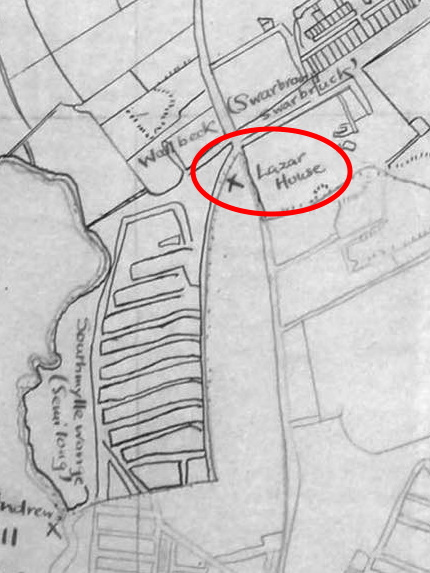
However, one further piece of secondary evidence exists that suggests the hospital was located in Northampton on the narrow triangle of land between Semilong and Kingsthorpe Road in Kingsthorpe Hollow. A field name survey was conducted in 1932 by pupils of Kingsthorpe Grove schools and an accompanying map was produced. This shows the Leper hospital (Lazar House) in the area bounded by Arnold Road and the junction of Semilong Road and Kingsthorpe Road. There is no evidence supporting this claim in the paperwork with the map and project, so can only be assumed to be a conjectured location as 600 years had passed from the last documented record of the hospital and the school survey.
I am indebted to Mary Pilkington for her help and local research in connection with this post.
- Lee, “A New Theory of the Origins and Early Growth of Northampton.”
- Adkins, The Victoria History of the County of Northampton, 1:293.
- https://gazetteer.org.uk
- ”Henry IV [1367-1413] – Quod Henrus Coup de Northn legavit in testamento suo tres acras terr’ arabil’ jac’ in campis de Kyngesthorpe super stadio vocat’ Sowthmyllewonge.” Glover, Kingsthorpiana; or, Researches in a Church Chest…, 25.
- ”Walterus Delepert emit de Johne Pekke Ballivo ville de Kyngesthorpe dim’ acra terr’ in stadio vocat Sowthmylnewonge” Glover, Kingsthorpiana; or, Researches in a Church Chest…, 25.
- Northampton Mercury – Saturday 11 May 1889, page 6
- ”Lot 2 – All that substantially erected Messuage or Tenement, situate at or near Wall-Bank in the parish of Kingsthorpe” Northampton Mercury – Saturday 01 May 1880, page 4
- Adkins and Serjeantson, The Victoria History of the County of Northampton, 2:162.
- Linc. Epis. Reg. Bishop Dalderby’s Memoranda, f. 40. [, Lincolnshire Archives, Ref.: DIOC/REG/3]
- Linc. Epis. Reg. Bishop Burghersh’s Memoranda,f. 78. [Lincolnshire Archives, Ref.: DIOC/REG/3]
- Serjeantson, “The Leper Hospitals of Northampton.”
- Coroner’s Roll (Northants.),No. 113, M.11
© Copyright : Graham Ward. All rights reserved.